
This article is about:
01
Avalanche warning services
Avalanche warning services are responsible for monitoring snow and avalanche conditions at the regional level across the Alpine area, and they do not assess avalanche risk at the local level. Based on analyses of the snowpack, meteorological data, and field observations, a daily avalanche forecast is produced that evaluates the avalanche danger within predefined warning regions of at least 100 km².
This flow of information is essential for informing the public about hazards associated with activities such as freeriding, ski touring, or winter hiking, carried out in open terrain, not subject to specific forms of control or management. However, the civil protection system has additional responsibilities as well. A central task of an avalanche commission is to provide decision-makers with critical information relevant to civil protection—information that is not directly related to mountain sports.
02
The avalanche bulletin: an essential communication tool
One of the most important and widely used tools for communicating avalanche danger is the avalanche bulletin. Its structure is conceived as an information pyramid, where the danger level constitutes the top, followed by increasingly specific details, designed to meet the needs of users with different skills and purposes.

At the top of the hierarchy is the danger level: a general indicator that attempts to describe the situation in broad terms (e.g., “low”, “moderate”, “considerable”, “high”, “very high”). Each danger level is assigned a distinct symbol and colour code, defined Europe-wide by the European avalanche Warning Services (EAWS). This enables clear communication to a wide range of users.
Following the danger level, the avalanche problems are described. These already provide a more detailed understanding of the avalanche situation and are indispensable, for example, four tour planning.
Next comes a more comprehensive textual description of the situation: the assessment of avalanche danger, the characterization of the snowpack, and further detailed information, including model outputs and measurement data. The latter can be considered the raw data used to produce the bulletin itself.
Presenting information according to this pyramid structure is intended to meet the needs of users with different levels of knowledge and different objectives.
03
Avalanche danger assessment on a local scale – the avalanche commissions
While avalanche bulletins provide valuable information at the regional level (with the smallest unit of micro‑regions being roughly 100 km²), certain situations require a specific and separate local risk assessment. A typical example is the evaluation of known avalanche paths located near settlements, roads, railways, or other critical infrastructure. The local assessments carried out by expert members of avalanche commissions in their advisory role support the responsible decision‑makers—such as mayors at the municipal level—in making well‑informed decisions when dealing with avalanche‑related issues.
Because of these small‑scale (local) assessments conducted by avalanche commissions, discrepancies may arise when compared to the regional hazard evaluation provided by the avalanche bulletin. This distinction is not necessarily contradictory; rather, it is inherent to the nature of the task. Detailed assessments of individual slopes may differ due to microclimatic conditions. Nevertheless, both assessments—regional and local—are indispensable tools for comprehensive and effective avalanche risk management.
Following the principle of the information pyramid used in avalanche forecasting, the assessment at the local level can also be represented as a pyramid, but inverted: starting from the regional danger level and the incoming field data, commissions gather increasingly detailed and specific information for their assessment area, including the definition of the avalanche problem. The analysis then focuses more and more on identifying observed or expected avalanche activity at the local scale, in order to evaluate potential impacts on people, buildings, and other infrastructure, and to advise the relevant decision‑makers on any necessary measures.
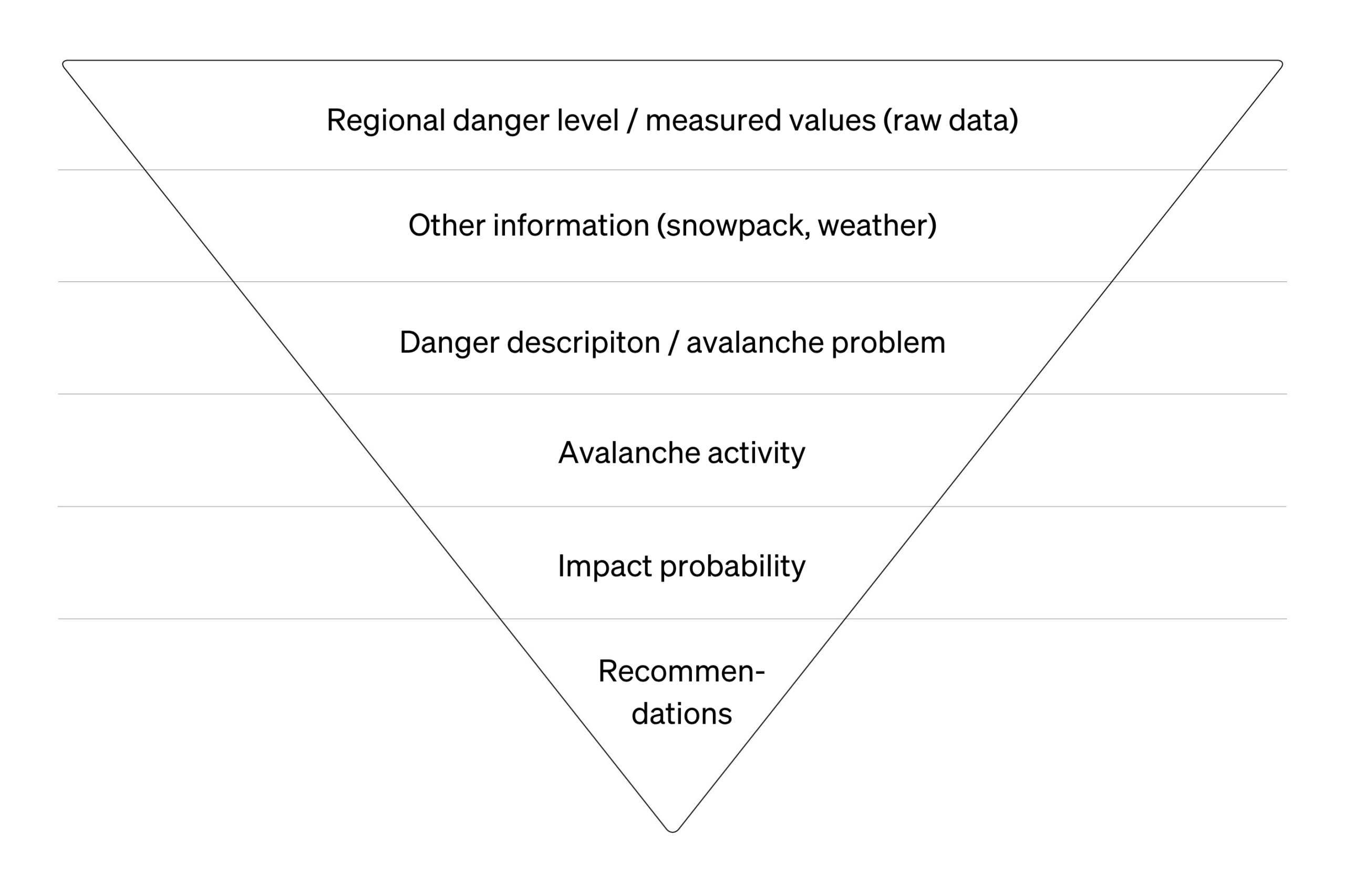
At present, no Europe‑wide, uniform standard exists for assessing avalanche danger at the local level, unlike the largely implemented harmonized approach used for regional avalanche forecasting. What has been established are several requirements formulated by the EAWS, which are to be regarded as a foundation for ensuring a modern and well‑organized risk assessment at the local scale.

In summary, there is a clear spatial distinction between regional avalanche forecasting and the work carried out by avalanche commissions. While avalanche warning services focus on analyzing and communicating the general avalanche danger at the regional level, avalanche commissions are tasked with assessing avalanche risk at the local scale.
Cover photo: © Sarah Graf | snow institute