This article is about:
01
Static and dynamic information
To assess the avalanche situation as accurately as possible, it is crucial to have a thorough understanding of your assessment area, including avalanche paths, local terrain features, and weather conditions—and how these factors interact.
Knowledge of past avalanche events – and therefore of the terrain’s potential under certain conditions – is particularly important in this context. Nevertheless, it is essential for avalanche commissions to gather information from a wide range of reliable sources. In this regard, static information refers to data that does not change at short intervals (e.g., daily), such as:
- Hazard zone maps (see “Spatial planning instruments”)
- Avalanche cadastre (see “Spatial planning instruments”)
- Forest maps
- Slop angle maps
- ….
On the other hand, dynamic information refers to data changes rapidly over time or at regular (short) intervals. Examples include:
- Weather data: weather forecasts and raw data collected from weather stations located in the commission area or other areas of interest
- Snow and avalanche data: the avalanche bulletin on a regional scale or snow simulations models
- Webcams
- Observations:
Daily observations: fixed monitoring stations (snow observations fields)
Occasional observations: professionals and recreationists conduct observations so that any important information regarding snow conditions and potential avalanches can be reported using platform’s like SNOBS.LIVE, AINEVA or others. - Avalanche scenario maps: maps showing avalanche simulation results connected to avalanche bulletin.
- Avalanche criticality bulletin: it is an Italian civil protection forecast tool that assesses the risk of avalanches in inhabitant areas on a regional scale.
02
Workflow of perceive
The perceive phase of the avalanche commission’s work can again be divided into two steps: first, understanding and interpreting all available data as described above and second, conducting additional on-site observations when necessary.
The flowchart shown here reflects the entire workflow of the avalanche commission. The first two steps – “daily base check” and “check in the field” – belong to the perceiving phase of the process. In many cases, weather a potential avalanche hazard exists can be done solely by analyzing the available data (daily check). Thus, the question of whether a “(potential) avalanche problem” exists can usually be answered relatively quickly with “YES” or “NO”. If the answer is “YES”, the next step is to verify this assessment through terrain-based observations (check on site).

Field observation activities require the intervention of the members of the avalanche commissions and represent a crucial step for validating and questioning – or confirming – the information derived from available data sources, such as the regional avalanche bulletin. These observations may differ from those made by recreationalists.
Observations include conducting snow surveys at locations that offer both representative conditions and adequate safety. These surveys may involve stratigraphic and temperature profiling as well as snowpack stability tests. Simple observations, such as checking whether the snow is dry or wet, can already provide valuable information for avalanche commissions (see “Basis of snowpack analysis”).
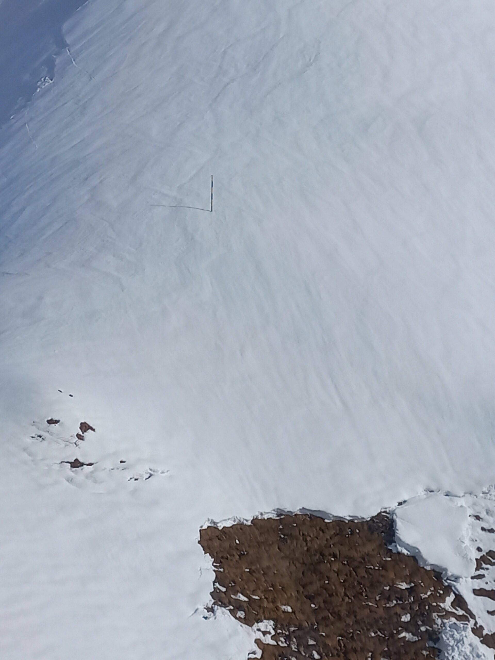
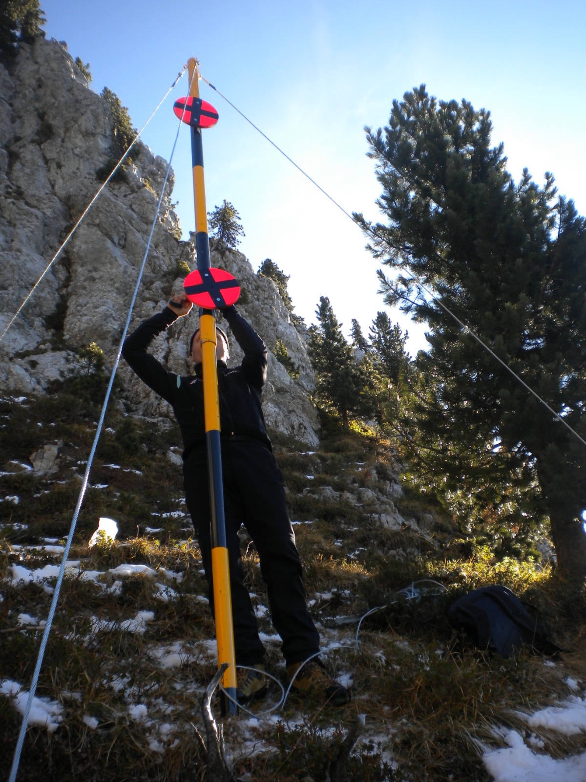
“Special” observations methods used by avalanche commissions include, for example, snow poles. These are graduated rods with alternating yellow and black bands, each typically 50 cm high, that allow a visual estimation of snowpack depth. Frequent monitoring of these poles makes it possible to assess the increases and decreases in snowpack thickness throughout the winter season. They are installed at strategic, highly visible locations such as open slopes, ridges and bumps. Observation points are usually situated in safe places on the opposite side of the slope or at the valley bottom. In some cases, the poles can also be monitored via webcams or during helicopter inspections.

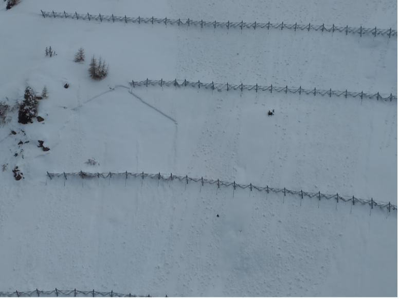
Active mitigation measures can also offer useful information: the quantity and distribution of snow retained by these structures provides information on the dynamics of the snowpack and its evolution during the winter season.
Other field observations may include photographic documentation of relevant such as localized snow accumulations, deposits on trees or buildings, the presence of cornices, signs of wind activity on the snow surface (sastrugi, etc.), as well as recent or ongoing avalanche activity.
Following the evaluation of current conditions – and any required field observations – the next step is a detailed assessment of the situation, with particular focus on determining the current avalanche risk within the designated area (i.e., the avalanche commission’s territory). The assessment process is outlined in the article “Assess: reference scenarios, threshold values, operational limits, and uncertainties”.